![]()
INVEST IN CYPRUS

Cyprus: The Real Return
>
Country profile
Cyprus Country Report for the year 2013
Finance Cyprus Investment Guide & Business Directory
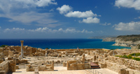
Location and Area
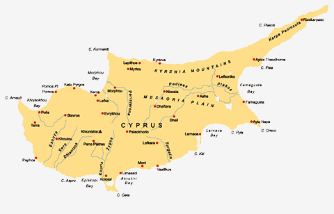
With an area of 9.251 sq.km extending 240kms from east to west and 100kms from north to south, Cyprus is the third largest island in the Mediterranean after Sicily and Sardinia. It is situated in the far eastern basin of the Mediterranean, at the crossroads of Europe, Africa and Asia. Cyprus is 65 km south of Turkey, 96 km west of Syria, 385 km north of Egypt and 328 km west of Israel. The strategic location of the Island has played an important role in its continuing development into a centre for international business and investment.
Topography- Geology
Two mountain ranges, the Troodos Range and the Keryneia Range, run from east to west across the island separated by the central Messaoria plain.
The densely forested Troodos Range in the south-west is a dome-shaped highland dominated by the island´s highest peak, Mount Olympus, at 1.953 metres above sea level. The entire Troodos massif takes up approximately one half the area of the island and constitutes the largest volume of ophiolite rock in the world. This unique mountain range consists of part of the earth´s upper mantle, thrust upwards from the primordial seabed many millions of years ago. It is of great interest to geologists and allows access to geological strata that would otherwise remain concealed beneath the sea.
The narrower Keryneia Range in the north , mainly of limestone, rises up to 1.024 metres and is also known as the Pentadaktylos- or Five Finger mountain. It is made of a succession of mostly allochthonous sedimentary formations ranging from Permian to Middle Miocene in age. Karpassia, the northeastern part of the range, is a continuation of Pentadaktylos consisting of hills, slopes and valleys free of foldings and other tectonic features.
The central Messaoria plain has a low relief and was formed during a very recent chronological period (holocene).
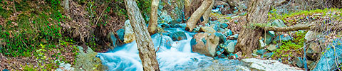
Cyprus is almost surrounded by coastal valleys where the soil is alluvial and fertile, suitable for agriculture. Arable land in Cyprus constitutes 46,8% of the total area of the island. Rivers are seasonal and only flow after heavy rain.
Climate
Cyprus is the warmest island in the Mediterranean. The mean daily temperature in July and August ranges between 29°C on the central plain to 22°C on the Troodos mountains, while the average maximum temperature for these months ranges between 36°C and 27°C respectively. Winters are mild.
The island, on average, enjoys more than 300 days of sunshine every year, and the rainy season is confined to the period between November and March. Snow occurs rarely in the lowland and on the northern range of Keryneia but falls every winter on ground above 1.000 metres on the Troodos Range, usually occurring by the first week in December and ending by the middle of April.
Natural Environment
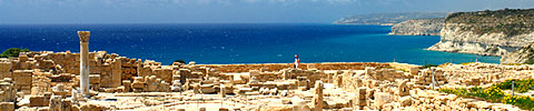
The coast of Cyprus is indented and rocky in the north, with long sandy beaches and numerous coves in the south. The northern coastal plain is covered with olive and carob trees and backed by the steep limestone Pentadaktylos mountain range. In the south the extensive Troodos massif is covered with pine, dwarf oak, cypress and cedar trees. Seventeen per cent of the island is woodland. Between the two ranges lies the fertile Messaoria plain.
The flora of Cyprus is unique and constitutes a truly outstanding botanical heritage. With an estimated 1.800 species of flowering plants, 8% of which are found only on the island, it is a paradise for botanists.
The arrival of animals on the island has long been a subject of fascination for zoologists. Evidence suggests that the first animals were pigmy hippopotami and elephants which swam to Cyprus. Apart from certain species of mice and shrew, they remained the only inhabitants of the island until the arrival of man. The present-day fauna of Cyprus includes 25 species of mammals , 26 species of amphibians and reptiles, 365 species of birds ( though only 115 breed on the island) and a great variety of invertebrates while the coastal waters of the island give shelter to 197 fish species and to various species of crabs, sponges and echinodermata.
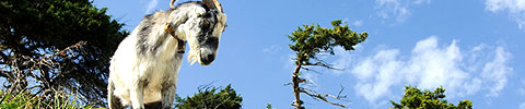
The largest wild animal found on the island today is the moufflon (Ovis orientalis ophion), a rare type of mountain goat unique to the island. It is strictly protected and its population has revived from near extinction to about 2.000 animals at present. It is the symbol of the Republic of Cyprus and is used on its coins.
Each year Cyprus is used as a stopping off point by millions of migrating birds traveling between Europe and Africa, something that has been observed since Homeric times. The birds are attracted by the island's two salt lakes at Larnaka and Akrotiri.
Other seasonal visitors to the island include the Green and loggerhead turtles (Chelonia mydas and Caretta caretta) which travel to the island's sandy beaches each year in order to lay their eggs. A successful conservation project was launched in 1978 in order to protect these two species. The programme, which includes a hatchery, is a model one in the Mediterranean.
Population
According to data from the Statistical Service of the Ministry of Finance, the total population of Cyprus was 892,400 at the end of 2009 of whom 75.4% (672,800) are considered to be members of the Christian Greek Cypriot community and speak Greek.
Of the remainder, 10% (89,200) belong to the Moslem Turkish Cypriot community and speak Turkish, and 14.6% (130,400) are foreign workers and expatriates residing in Cyprus.
While the majority of the Greek Cypriot community are members of the Autocephalous Greek Cypriot Orthodox Church of Cyprus, 1% are actually members of the Armenian, Maronite and Latin churches. Under the provisions of the 1960 Constitution these religious minorities chose to be considered members of the Greek Cypriot community.
Greek and Turkish are the official languages. English is widely spoken but other languages are nowadays becoming popular as well.
Towns
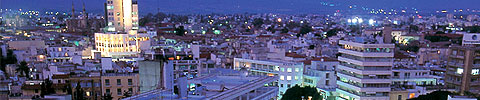
The capital of Cyprus is Lefkosia (Nicosia) with a population of 315,400. It is situated roughly in the middle of the island and is the seat of the government as well as being the main business centre.
Lefkosia has the unwelcome distinction of being the only divided capital city in the world. Since the Turkish invasion of 1974 its northern part is under occupation and is separated from the south by a United Nations patrolled buffer zone.
The second biggest town on the island is the main commercial port of Lemesos (Limassol) in the south of the island, also a popular tourist resort, which has a population of 230,800.
The coastal town of Larnaca in the south-east has a population of 134,400 and is the island´s second commercial port and also an important tourist resort. To the south of the town is situated Larnaka´s International Airport.
Pafos in the south-west with a population of 77,800 is a fast developing tourist resort and home to the island´s second International Airport.
In the Turkish occupied area, Ammochostos (Famagusta) in the eastern part of the island was the centre of the pre-1974 tourist industry. Other main towns which are also under Turkish occupation are Morfou in the north-west and Keryneia in the north.
Make business in Cyprus
CYPRUS TRADE CENTRES

Country profile


© Cyprus Embassy Trade Centre in Berlin